17 FEBRUARY 2025: A 1000-acre (404ha) pilot project restoring ancient floodplains in marginal Queensland country has seen decades of barren claypan transformed to deep green.
It’s been a year since a five-person crew spent a week cutting contour banks around the seasonal Stonehenge Creek at Wellclose station, but already staff at the Australian Country Choice property have noticed major changes to the landscape and soil health.
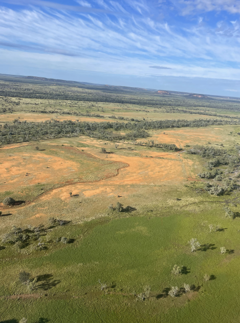
A blush of green pick has spread across flats that had never before offered a blade of grass in this 400mm annual rainfall county.
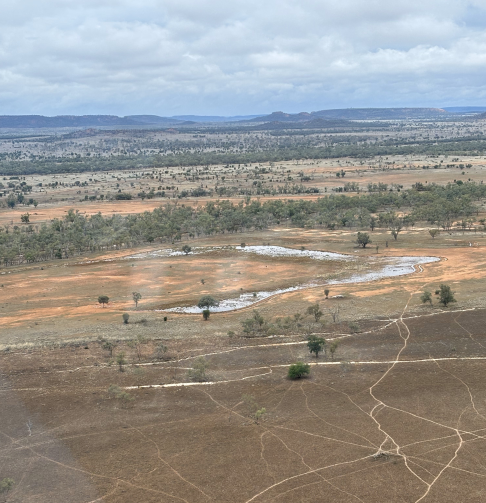
Hard-crusted degraded red soil claypan has transformed to deep cracking black clay that is soaking up and retaining sub-surface moisture, said Grant Keane, senior manager of the 225,022ha beef and goat property.
“Previously it was red and flat like a tennis court and hydrophobic. It had ceased to function as soil. But now, inside the contour banks, the soil colour has turned black; it has started cracking and taking in moisture.
BELOW: The site before and after the contouring works.
“We’d had no rain since March, but when we took a 30cm soil core sample in August and put it in a plastic bag, the bag straight away started misting up with the sub-surface soil moisture. Moisture retention has been significant.”
And in the sumps of the contour banks (sometimes called swales) native perennials are self-propagating. “These areas were bare earth for 99% of the year,” said Grant. “There’s been a huge uptick of vegetative matter.”
The increase in ground cover is boosting general soil health, he added, with more evidence of life below ground . “It’s bringing back all the microbiology that helps improve soil health,” he said.
He also hopes the contour banks will help prevent the erosion gullies carved by fast-flowing water coming off hills around the site.
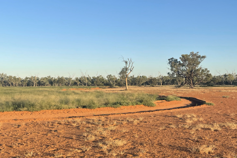
Calculations indicate that the work, costed at about $33,000, could see an additional 22,000ML flowing across flood plains before the water returns to the creek. The contour banks, measuring up to 5km long, slow water flow from 1.5 days to between five to 10 days. They have doubled the area of inundated land, said Grant.
“It’s a cool piece of work.”
He developed the concept with ACC’s Sustainability Manager Joel Bentley and Charleville-based regeneration consultant Glenn Landsberg who used his locally adapted keyline design theory.
BELOW: Simple contour banks slow the water flow.
Before starting work, the team looked at five potential sites and worked out a cost/benefit analysis for each.
Grant said: “A key feature were the dead coolabah trees that gave us a hint of where to start. We could see these old coolabahs that had been swamp trees. So we could see where ancient swamp lands were. And we could see younger gidgee growing there now; those trees don’t like swamps. This was something that Glenn figured out.”
They selected an area that included holding paddocks around some yards. “It had been a place of high soil fertility that had been degraded,” Grant said. “I excluded grazing until things were established and then we let cattle graze to about one-third of biomass and let them tread the rest in. We had a rotation period of about 90 days grazing at high intensity, amounting to the total stock days they’d normally get in a full year, and then spelling the paddocks the rest of the year.”
And lastly, to see the immediate results of their efforts, the team selected an area along one side of the creek. The other side was left untouched – and the comparisons are obvious, said Grant.
“I’m pretty excited about it,” he said. “And I’m pretty proud of it.”
He admits the work has meant new learning. He has had to undertake some training and take on board some new ideas. “It can be a bit controversial. But there’s more farms up here taking on the idea,” he said.
Now the property team is rethinking how they contour roadsides during routine maintenance, he said. “We’re trying to incorporate similar works into our road maintenance, whenever we go through and see an eroded gully. We’ve got the equipment there to do little projects along the roads.
“And wherever there’s downed scrub, we lay it in contours to slow the water’s flow. We are now very aware of water’s impact on the land.”